
Saturday, June 2, 2012


Update on Tire
The man says the tire can be repaired. I hope to be on the road by noon. My iPhone map says 327 miles to home. That would be nice. I hope the weather holds. It is beautiful in Tok this morning.
What The Morning Brings
Rear wheel off. Waiting for the tire repair man to show up.
Lots of dew this morning too! Had to beg a cardboard box from reception


Lots of dew this morning too! Had to beg a cardboard box from reception
Friday, June 1, 2012

It's A Forecast, Not A Promise
The weather forecast was little to no wind and sunny skies all the way to Tok, with clouds and maybe snow tomorrow.
I snort in the weatherman's general direction. I poot that way too.
Snow, my friends. Snow. And colder than a banker's heart. My investment in the heated vest paid dividends. Without it I would have been forced to stop or turn back.
Did I say colder than a banker's heart? I meant to say it was colder than Russo's heart.
There was also a several mile stretch of construction that slowed me down quite a bit. Nonetheless I find myself in Beaver Creek for lunch at about 3:30. Lunch looks good.
Thursday, May 31, 2012
Not much to report
It was a cold and windy day. It started out nice enough, but I could see weather building up ahead. I thought maybe after I got across the Continental Divide the weather would get better, but it only got worse. By Whitehorse it was blowing 20 mph out of the southwest with higher gusts.
It was the higher gusts that made me stop. The weather in Haines Junction was about the same as Whitehorse, but the forecast was for the winds to abate over night in both places. I was on the ragged edge of being able to control the bike so I decided to stay here.
I have some non-descript photos I took early in the day. After 10:30 I didn't feel like doing anything but holing up until the wind dropped.
I last drove this highway in May, 1982. The road I see today evokes no memories of the road I saw in 1982. The one place I kind of remembered, just north of Johnson's Crossing, still runs through the same cut, but where there was a stretch of potholes 40 yards wide and a half mile long, there is now a wonderfully paved (ok, chip sealed) section of roadway. I like the road better.
Tomorrow I am aiming for Tok, just shy of 390 miles. That is going to make for a long day. I hope I can hold up to it.
You will note the flag snapping smartly on the pole on the bow of the Klondike. They have built a nice park for it now.
Wednesday, May 30, 2012
Bears and Bison-The Ride to Watson Lake
I have not seen so many black bear. I actually lost count at a dozen. First I saw a sow with two cubs, then nothing for awhile, then here a bear, there a bear, every where a black bear. And one brown bear. Cinnamon, he was, nose down in the dirt so I couldn't make out for sure if he was a griz type brownie or a black bear in the brown phase.
Not too far out of Ft. Nelson was a large electronic sign warning of bison. It was a huge sign, which is appropriate for these grand animals. I saw maybe two dozen, probably more. The bulls were absolutely huge. I could tell they were bulls because, well, they were huge. The cows were sized appropriately for the bulls. At least I think they were. I didn't see any calves.
I also saw many sheep from and after Summit Lake (highest point on the Alaska Highway). They were right down on the highway, and I mean right down on the double yellow line. At least two of the rams were full curl. Many ewes and kids. And there was one caribou, also in the middle of the road. It got confused when it heard the motorcycle and I thought it was going to run right over me. But it finally got its nose up in the air in that curious ungainly way and it trotted down the middle of the road and off into the scrub.
The road is through a forest of mixed birch and spruce, with an occasional stand of pine. Willows and poplar have their place along the roadways and rivers. It is very much like interior Alaska except for the pine. The road itself varied in width and shoulder size but it was all chip seal. Now some of that chip seal was okay, and I could do 50-60. Most was not. Some was downright torn up, particularly up high. That required constant attention and careful riding. I think I only averaged around 40 mph today.
And now, the weather report. Meredith chortled when she told me it was going to get colder the closer I got to home, so I donned my merino wool naughties, a vest, and turned on the hand warmers. Good thing I did all that, as it was cool and breezy. In the morning, I played the role of the Itsy Bitsy Spider in the childhood ditty of that same name. In rain, out of rain. In rain, out of rain. But out came the sun and dried up all the rain, so I went up the spout again.
I'm bunked up in The Big Horn Hotel. Big Horn. That's two words. You have to see it to believe it, so I'm posting pictures of the hotel room and some sights along the highway.
Tuesday, May 29, 2012
Lightning Strikes
Today's ride was both fun and not. The ride to Dawson Creek was great: fast and little traffic. The roadway was excellent with wide shoulders and good surface. At Dawson Creek, the road turns back westnorthwest to Ft St John, and continues to be excellent. But I picked up a crosswind that had been at my back from Chetwynd to Dawson Creek, and that with lots of big trucks slowed me down.
Out of Ft. St. John, the road is great for quite awhile, but then the shoulders narrow and much later the surface changed for about 30 miles to chip seal. Chip seal and patches and rough road. That just vibrates the snot right out your eye sockets. And slowed me down. But I saw another black bear in addition to the two I saw yesterday. That was nice.
A word about wildlife. I've seen quite a bit, including 2 whitetail deer walking down the main street of Winlock, Washington, mule deer in Oregon, and Mt. Goats of a brownish color (could have been mud, it was raining and snowing at the time) in Idaho. Or maybe it was Montana because their borders are very close as you know. And of course herds of deer and antelope But the bears were particularly striking. Very healthy looking. Winter must have been mild, or maybe tourist season started early.
As I rode along, I could see dark clouds forming off to the northwest. Why, northwest was my general direction. Did I mention it was black all the way to the ground? My experience-based training in meteorological matters instructed that black to the ground was weather to avoid. Off to my right front were clouds with rain drift, and sure enough, the road drifted more to the north and north east, and pretty soon I was riding through light showers and places where it had recently rained. The air was fresh and scented, sometimes of the woods, but often a floral scent the origin of which I could not identify.
And then came the lightening. The black clouds were rent with lightening strikes. I couldn't tell how near or far because the helmet and road noise blocked the sound of thunder, but I could tell from the rain drift it was headed my way. And then it rained. As my hunting partner Dick would say, "Holy buckets!". The water came down, hit the ground and danced so high I was reminded of Mr. Bojangles. It was like riding on top of a sprinkler. So this slowed me down some more, and I was looking at the lightening and thinking I should maybe develop an alternative plan because the current plan just wasn't working well, when the road ran me right out from under the rain, and put the dark sky and lightening off my left shoulder for the last 50 miles into Ft. Nelson.
Speaking of dark skies, dark as the wing of a raven, I want to revisit my comments likening the raven to lawyers. On further reflection, I think the owl, the osprey, the eagle, all of which are scavengers or predators, are more like the lawyers, and the ravens, wearing their black cloaks, are more like judges, who take great pleasure in bedeviling the lawyers. I can say this because it is highly doubtful that any judicial officer us following this blog (unless Joe mentioned it to The Eye).
So I made it into Ft. Nelson. I didn't like the look of that black sky, off to the west now, the direction I had to go. I had put in 350 miles or so, so I decided to get a room. I pulled into the Lakeside Inn and asked for a room with wifi. No rooms with wifi. Only the lobby has wifi. And no other hotel in town had wifi, offered the young man at the desk (I doubt he could have flung that spider as far as I had done). But did they have a nonsmoking room? First yes, then, unfortunately no. But the Super 8 next door was called, and they had a nonsmoking room with, Alors!, wifi! Arrangements were made.
I went outside to ride next door, and the black cloud's grey brother had descended on Ft. Nelson. I mean high winds, heavy rain, blowing dust. I could barely stand, much less ride. Just then a Lakeside Inn van pulled in and the driver yelled to pull the bike under the portico (he may have said "portcullis" but I didn't see one) so it wouldn't fall over. So I did.
I went back in and the driver, a very nice man, had Hazel the Clerk put me in a suite (nonsmoking) for the price of a regular room, which, with all taxes included, cost as much as a good dinner for two in Anchorage.
So here I am in the suite. I had Mountain House spaghetti (with meatballs mind you) for dinner. It is still raining like Mr. Bojangles outside. I am attaching some pictures of the rain which don't do it justice, and one of the highway because it is spectacular.
Mostly I am happy and thankful to be dry and away from lightening. I don't like lightening. I like electricity to be in the walls where it belongs, and stays there until you put a plug in the wall. Much more civilized.
Oh, the suite? Standard room with a faux fireplace and a jacuzzi in the corner. Who puts a jacuzzi next to their bed? Crazy stuff, just crazy.
Spiders of Lac La Hache
While reading in the tent before going to sleep, I spied a black spider heading down into my riding pants. Of course it was quicker than me, and I couldn't reach it before it disappeared. A mental note was made to check my pants carefully in the morning.
With unusual clarity of memory, I did just that, opening all vents, zippers and the like, and removing all the pads, etc. No spider! All was well until I went back to the tent to pack it up. There, scurrying around on the floor of the tent, was a brownish spider. Not small, not large, just spiderish. BROWN RECLUSE!! my mind screamed.
Quicker than the Golden Snitch I grabbed a riding glove, caught it 'twixt trembling thumb and forefinger, and in a very girly fashion flung it as far as the aerodynamic qualities of the arachnid allowed. Which in my view was not far enough.
I have lost my fondness for the Big Country RV Park.
And that was how my Memorial Day started. It ended with rain squalls and micro burst winds along the Pine River on the way to Chetwynd where I spent the night. The road was through logging country, and they are hauling wood all day long. The logging industry seems alive and well in B.C. I guess they don't have spotted owls. Probably had them for dinner. Speaking of owls, I saw one on the ground in a field this morning being harassed by several ravens. I've seen ravens do the same thing to other birds, including osprey and bald eagle. Very interesting behavior, and I conclude ravens are related to lawyers.
There is also a great deal of mining activity and exploration around Chetwynd. Plenty of economy there.
I did not ride into Dawson Creek to take a picture of Mile 1 of the Alaska Highway, but rode straight on to Ft. St. John, where I stopped to check email and write this post. About 1500 miles left to go to be home. I won't even talk about riding the bike over the Peace River on a metal grated bridge. I just prayed the whole way (about half a mile) as the bike kept trying to tell me it wanted to fall over.
Hope to make it to Fort Nelson or further today, so I better get moving.
Sunday, May 27, 2012
Lac La Hache
I was up and out of the Red Apple without bullet holes in good time this morning, riding up the Okanogan River to the border. The road lies mostly near the river, but is bounded by orchards and vineyards. There were many fruit stands but none were open this early in the year.
The border crossing was uneventful, and I rolled on up to Penticton and then Peachville, where I took the cut-off to Merritt and Kamloops. The road up to Penticton was also lined with Orchards and vineyards, but added many tasting rooms. The names of the vineyards were all Italian sounding. They may have been owned by Italians, but the workers looked like Sikhs to me. There was a huge lake below the road to the east, and if there were a few more villas and Fiat 500s, I could have thought I was near Lake Maggiore.
The cut off to Merritt was over a pass that seemed to last forever. It was marvelous in that it was a 4 lane and very wide. Not much in the way of clean shoulders, but a few decent places to pull off. Eventually I dropped down to Merritt, then Kamloops, but the new highway bypasses them both by quite a bit.
From Kamloops to Cache Creek was a ride through another pass, this road not being as wide, but with sufficient passing lanes to allow traffic to flow. I stopped for fuel and food in Cache Creek, and to look at the map. My butt gets sore after about 250 miles, and I had 265 in at that point. But for me, Cache Creek was my first real step onto the Alaska Highway, and I wanted to get on towards home and Meredith, so I decided to ride until 5:00.
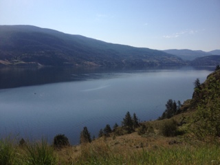
Just before 5:00, near Lac La Hache, I found the Big Country Campground and RV Park. I had to stop and camp here in honor of Big Country (APD Vice). It's a nice place, very well kept, but the Mosquitos are out. And it has wifi so I can post this blog.
Here are pictures of camp and the lower end of the lake (before the villas and vineyards).


The border crossing was uneventful, and I rolled on up to Penticton and then Peachville, where I took the cut-off to Merritt and Kamloops. The road up to Penticton was also lined with Orchards and vineyards, but added many tasting rooms. The names of the vineyards were all Italian sounding. They may have been owned by Italians, but the workers looked like Sikhs to me. There was a huge lake below the road to the east, and if there were a few more villas and Fiat 500s, I could have thought I was near Lake Maggiore.
The cut off to Merritt was over a pass that seemed to last forever. It was marvelous in that it was a 4 lane and very wide. Not much in the way of clean shoulders, but a few decent places to pull off. Eventually I dropped down to Merritt, then Kamloops, but the new highway bypasses them both by quite a bit.
From Kamloops to Cache Creek was a ride through another pass, this road not being as wide, but with sufficient passing lanes to allow traffic to flow. I stopped for fuel and food in Cache Creek, and to look at the map. My butt gets sore after about 250 miles, and I had 265 in at that point. But for me, Cache Creek was my first real step onto the Alaska Highway, and I wanted to get on towards home and Meredith, so I decided to ride until 5:00.
Just before 5:00, near Lac La Hache, I found the Big Country Campground and RV Park. I had to stop and camp here in honor of Big Country (APD Vice). It's a nice place, very well kept, but the Mosquitos are out. And it has wifi so I can post this blog.
Here are pictures of camp and the lower end of the lake (before the villas and vineyards).
Saturday, May 26, 2012
Dash to Tonasket
Well, maybe not a real dash. The ride from Lowell to Lewiston on Highway 12 was really great. The highway runs beside the river almost all the way, with fresh air aplenty. It is mostly forested upstream, but as it nears Lewiston, it breaks out into the rolling hills that later become the Palouse. It is still the Lewis and Clark and Nez Perce Trail(s), and runs through the Nez Perce reservation. John Mark would never get from one end to the other because of all the historical sites he would have to read.
At Lewiston, the road to Spokane and points north is Highway 195, and it leaves 12 and turns north before you get to Lewiston proper. Not only does it turn north, it goes up, up, up into the Palouse. Wow, what wonderful rolling hills, green and brown in turn, carved by the highway and just pretty as can be. I should have taken a picture, but the wind was my companion again, requiring constant attention. It held my speed down to 40-50 miles per hour so I could maintain control of the bike. But all was well, and I made it to Spokane.
The wind stayed with me out of Spokane, but gradually lessened. I enjoyed the ride up 395 to Kettle Falls. Colville was nice, and they were having a car show in Chelewah. There was about a five acre park full of great looking cars. At Kettle Falls I picked up Highway 20, the longest Highway in Washington State, and a true Scenic Byway. There was no traffic going my way, and I just rode along at my speed enjoying th whole thing. It took me up to Sherman Pass, named after Sherman the cat, named n turn after William Tecumseh Sherman, an infamous general in the War of Northern Aggression.
I was trying to find a place to camp after Republic, but the campgrounds were full. I rode through a Forest Service campground at Bonaparte Lake, and it was a trip. There wasn't a vehicle there made after 1999, every site had at least a half case open on the table, and I heard dueling banjos through my helmet. The nearby resort of the same name was marginally better, but they were full too. So I rolled on.
I couldn't find a campground anywhere, so I came on to Tonasket. It is a pretty little place, but I think I made a bad choice of motels. It was quiet until about 5 minutes ago, when the adjacent room was rented to some screamers. Two people who are unhappy with each other. I hope they don't have guns. I don't think the wall will stop a bullet.
Tomorrow I head up to Canada and the Alaska Highway. With 2295 miles to go, I should be home in a week. And not a minute too soon, I might add!
Friday, May 25, 2012
Lolo to Lowell
JRon the Romaniac predicted snow at the top of Lolo Pass, but the Idaho DOT camera showed overcast but dry roadway with a temp of 40 degrees. After my adventure in the snow in Lost Trail Pass, I wasn't wanting any more of that today. When I stopped at the Country Store in Sula to get coffee and warm up after the snow adventure, the clerk advised me to just ride to Missoula and hole up for the weekend because the forecast for the weekend was worse weather to come (something about 18 inches of snow at Glacier). So when I got to Lolo, 9 miles shy of Missoula, I checked the camera again, and the forecast. It looked good enough to sneak on through.
Wrong.
More snow, more wind. But this time I didn't stop at the summit to take pictures because it was cold, windy, and slicker than a city lawyer. JRon was right.
The country from Lolo to Lowell is all forested, and the road, Highway 12, is in a river valley on both sides of the pass. This road follows the Lewis and Clark trail, as well as the Nez Perce Trail. Very historical. Very pretty, even in the rain.
I finally ran out of rain about 20 miles east of Lowell. This river (which is running very high right now) is a rafting and kayaking destination. Lots of rafters and boaters and all their attendant gear and infrastructure. When I got here, I decided to stop and see if I could get a room. This is it. I like it.


Thursday, May 24, 2012
Idaho!
After sponging off Eric for two days in Salt Lake (Bountiful, to be precise), this morning I headed north on I15 to Ogden, where I diverted to 89, then 91. The road over the pass to Logan was really nice, as the pass was broad and open. In fact, I've been in open country all day today with the exception of a striking little canyon just south of Challis.
I ran into rain squalls as I crossed the border into Idaho. Generally I missed them as the road seemed designed to meander between them, but I did get caught in one that started as rain, then hail, then snow, then rain again. The roads were only damp, and not slick, but the temps were in the 40s, and I just wasn't dressed warm enough.
At Blackfoot or thereabouts, I picked up 26 and headed almost due west to Arco. Along that way, right after 20 joins it from the east, is the first atomic energy plant built in the U S. it is no longer active, but very interesting. As I have visited it before, I didn't stop this time. At the nearby rest area I encountered two young men cycling across the U S. They were nice, and figured they have about 6 1/2 weeks left to go. They were pretty excited that yesterday with the wind at their back they were doing about 20 mph. Today, however, the wind was on their face. They weren't as excited about that.
In Arco, I turned north on 93, and it too is a highway with spectacular scenery. In the south, it is in the Lost River Valley, which is broad, bounded by low mountain ranges, with farms and ranches (mostly the latter) scattered about. The road climbs in straightforward fashion through a little pass at about 7300 feet, and then drops into another very broad valley, through which runs the Salmon River. It too has ranches, lots of stock, and is bounded by what appears to be higher, sharper mountains. It is hard to see the tops because of the low clouds.
Here are a few photos of the rain showers: one in front, one behind. The third photo is just of the general type of views in the valley of the Lost River.
Oh, I stopped in Challis (not Chellis) to warm up. I'm in a smoking room that really stinks. And is badly worn. It is squarely from the sixties. There is but one chair, old and worn, with a significant split in the seat. Overall, the room merits a D. Maybe even a D-.
I hope to get an early start tomorrow and get to at least Clarkston, Washington. But that's a little over 400 miles, so I may be optimistic. However, I did ride 345 today, so I can probably do it if the roads are good and the traffic is light.
Wednesday, May 23, 2012
Hoodoo Heaven
Bruce Canyon has sedate Hoodoos. Goblin State Park has silly Hoodoos. Film critics will recognize these Hoodoos from the Sci-Fi classic Galaxy Quest. 

Bryce Canyon
Wow, just gorgeous.
While the bikes were parked, I watched some tourists, Europeans, cluster around my bike as they photographed the Alaska license plate. Hilarious.


While the bikes were parked, I watched some tourists, Europeans, cluster around my bike as they photographed the Alaska license plate. Hilarious.
Revised Plan
I am going to take a run up to 93, and see what the weather is like. If need be, I can pick up 12 just south of Missoula and swing over to Clarkston. I can then either run up 395 through Spokane and into Canada on 95, or find my brother John and leave the bike with him and fly home. Options abound once I get further west.
It looks like rain covers all routes north. I am going to try to avoid the snow though.
The SPOT will start up again tomorrow so you can track me there. Keep those cards and letters coming, folks!
It looks like rain covers all routes north. I am going to try to avoid the snow though.
The SPOT will start up again tomorrow so you can track me there. Keep those cards and letters coming, folks!
Frozen Custard
Here in Bountiful, it's Nielsen's. In St Louis, Ted Drewes. Last night I had a concrete, tonight I had just vanilla frozen custard. Both were really good. I like Nielsen's because the staff is just as nice S Drewe's, the product is excellent, and it is not as crowded. Less parking though, but there is a drive thru, inside dining, and a walk up window. 

Subscribe to:
Posts (Atom)